24004 Views
Road Safety
Color is the most relevant factor when buying a car
Are lighter-colored cars safer than dark ones? What colors do European drivers prefer? And
The best way to get from A to B is not always a straight line, as the incredible stories of some of the highest roads on the planet demonstrate.
The roads through some of the highest mountain ranges, sierras or mountain passes in the world are always special places. In addition to their obvious usefulness in connecting point A and point B by the most rational route, that is, by old paths that became dirt roads and that, years later, were opened to traffic, there are also curious stories, some of them tragic, that have marked them forever. They are, in any case, places that arouse curiosity and hide incredible stories. They are the true “highways to heaven”, with permission from Michael Landon’s television series.
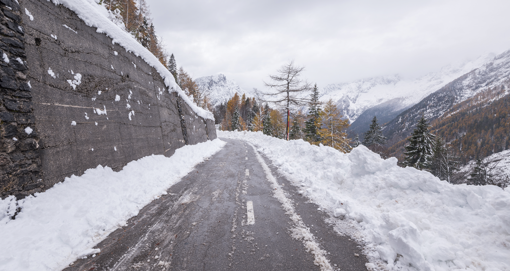
This is the case, for example, of the Vrsic Pass in Slovenia. It is by no means the highest road in the world, a title held by the Umling La Pass in India, at 5,793 meters above sea level, i.e., higher than Everest Base Camp. But Vrsic, which is at an altitude of 1,611 meters, tells a tragic part of the history of Europe and the world in its 50 kilometers.
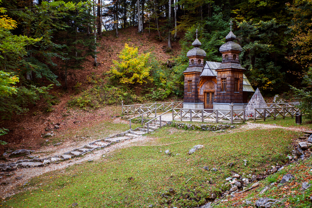
The road connects the towns of Kranjska Gora and Bovec and was built by Russian prisoners during World War I. These soldiers, captured by the Central Powers, suffered the worst conditions imaginable in terms of weather and physical demands. Many of them died, and a Russian chapel was built in their honor, which can be visited along the way.
This winding route through the Julian Alps in the north of the country borders Austria, with gradients of up to 15%. In fact, it takes about an hour to complete the entire section. The Vrsic Pass leads into the Soca Valley, an area worth visiting and a reward after all that effort, especially if you have decided to do the journey by bike. From the Vrsic Pass, where there are various hospitality establishments, there are numerous hiking routes and a wide range of adventure activities.
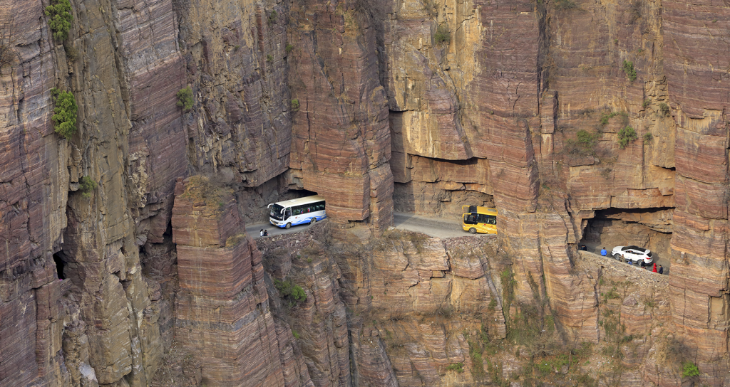
The Guoliang Tunnel, located in the Taihang Mountains of China, at an altitude of about 1,700 meters and in the heart of the Wanxian Shan National Park, is an incredible feat of engineering, dug by hand by the inhabitants of the isolated village of Guoliang. Before the tunnel existed, the only way out to the outside world for the villagers was a steep and dangerous staircase, the Stairway to Heaven, with 720 steps.
Motivated by the tragic death of a little girl who fell down this dangerous mountain road on her way to the only school in the area, 13 villagers, led by Shen Mingxin, began construction in 1972 using rudimentary tools. After five years of hard work, they opened a 1.2-kilometre tunnel in 1977, allowing vehicle access and improving the village’s connectivity.
The tunnel cuts through cliffs and has dangerous curves. It has also become a global tourist attraction, famous for its breathtaking views and thrill-seeking route. Although it was built by hand and was upgraded with safety measures, it is still considered one of the most dangerous roads in the world. The construction has transformed Guoliang into a modern tourist destination, with attractive and unique accommodations and trails for unforgettable hikes.
Romania is home to what experts say is the most beautiful road in the world, the Transfagasaran, 90 kilometers of curves of all kinds that cross the Fagaras Mountains between the regions of Transylvania and Wallachia, south of the Carpathians. It rises to more than 2,000 meters above sea level, and you can even visit Poenari Castle, where Vlad Tepes aka Vlad the Impaler lived, and eventually inspired Bram Stoker’s Dracula. To access the ruins of what was once his fortress, you have to climb a steep staircase of 1,500 steps.
Waterfalls, reservoirs with walls over 160 meters high and impressive views, especially on the descent, complete the attractions of this route, whose official name is DN7C. The unofficial name is Ceausescu’s Folly, after the dictator who promoted the construction of this road, which required 6,000 tons of dynamite and claimed the lives of 40 workers, according to official sources, although it is suspected that there were many more who perished due to the harshness of the working conditions.
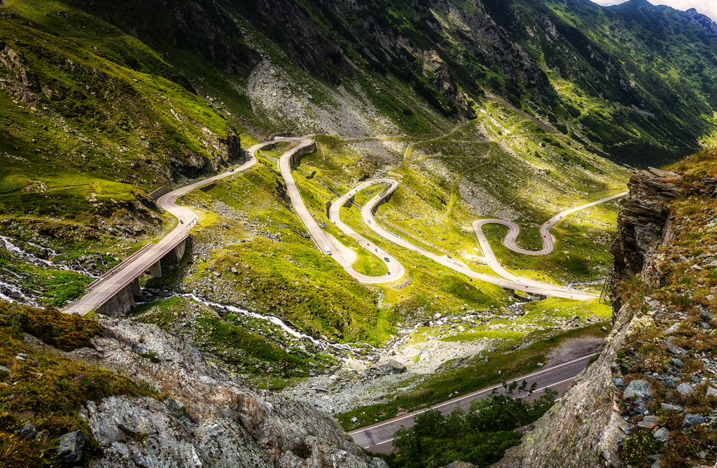
Construction began in 1970 and lasted four years. The main reason for this was the fear of an invasion by the Soviet Union, as it had done previously with Czechoslovakia, and the need for access through the mountains that would be difficult to block. To reach the Transfagasaran, a delight for lovers of mountain driving, whether by car or motorcycle, the best way is to travel to Pitesti from Bucharest and, from here, where the factory of Dacia, Romania ‘s national vehicle, is located, drive to Curtea de Arges. Then, put the car in first gear and explore.
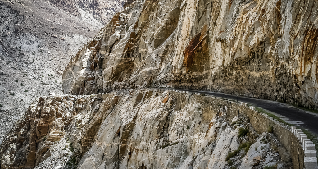
The Karakoram Highway (KKH) connects Pakistan and China along approximately 1,300 kilometers through the majestic Karakoram mountain range. Opened in 1978 after nearly two decades of arduous construction, its highest point rises to 4,693 meters above sea level. This monumental project has become a symbol of connection between the two nations.
The construction of the KKH was a huge challenge due to the difficult terrain conditions and extreme climate, with temperatures that can drop to -30°C. It is estimated that around 1,010 workers, 810 Pakistanis and 200 Chinese, lost their lives due to landslides, avalanches and accidents during its development.
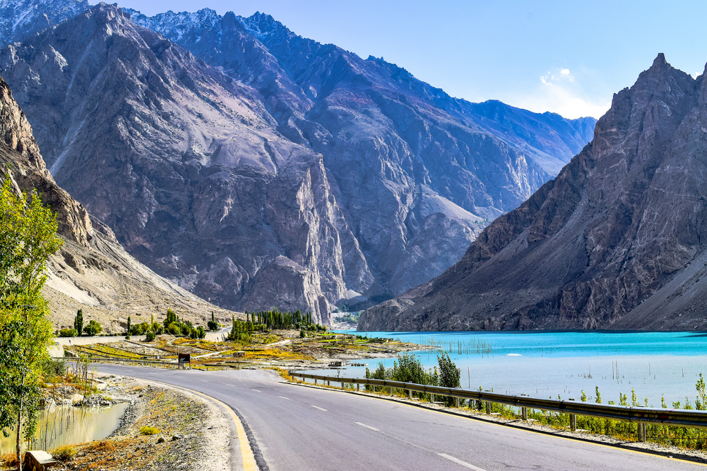
The KKH has played a crucial role in the region’s economy. By facilitating trade between Pakistan and China, it has promoted development and created opportunities for local communities. The highway is an integral part of the China-Pakistan Economic Corridor (CPEC), an infrastructure project that seeks to strengthen economic ties between the two countries.
Along the KKH, travelers can explore landmarks such as Khunjerab National Park, the Hunzao Valley, Attabad Lake — formed in 2010 by a landslide — and Passu Glacier, one of the most accessible and photogenic glaciers in the world. Today, the KKH is a hotspot for cyclists, motorcyclists and travelers looking for unique experiences. However, dangerous conditions and geopolitical conflicts in the region make this trek suitable for adventurers only.
Other roads, not so emblematic but higher up, can be considered the paved roofs of the world, such as the aforementioned Umling La in India, which requires a special permit from the district magistrate of Leh to be traveled; the Semo La pass in China, at 5,566 meters above sea level; or the Gyatso La pass in Nepal, the crown of a road that has two other points above 5,000 meters. This road, called the Friendship Bridge, links the capital of Tibet, Lhasa, with the border between China and Nepal, at the so-called Friendship Bridge. This name refers to the war that has been going on for more than 70 years between the two nations.
There are many roads that stand out for their elevation above sea level and, naturally, they are found in mountainous regions of the five continents. Such as, for example, the Viraco abra in Peru (‘abra’ is how mountain passes are known in some regions of Latin America). It is set at 4,926 meters above sea level in the Arequipa region, and links the cities of Viraco and Chuquibamba. Its tarmac is uneven, and it is a hotspot for accidents.
The highest paved road in the United States, which is open only a few weeks a year, is the Mount Evans Pass in the Rocky Mountains in the state of Colorado. Its highest point is 4,310 meters above sea level. Slightly higher, but also on the American continent, is the San Francisco Pass, which links the Argentine province of Catamarca and the Chilean province of Atacama. Heavy snowfall in winter regularly causes its closure, and it has become famous in the last decade because it has been part of the Dakar Rally in South America.
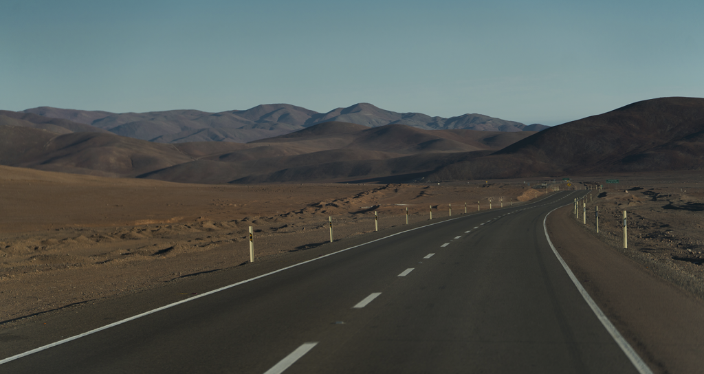
Higher up is the Portezuelo Paranal pass, in the Chilean region of Antofagasta, at 4,836 meters. The weather conditions in the area, with strong solar radiation and intense gusts of wind, as well as distances of up to 160 kilometers between service stations and the lack of mobile phone network coverage, require caution and planning when planning a trip along this route.
Write: Rafa Honrubia